Meteorology by Nigel Romany

go to Zoom Earth interactive weather map
(Android and Apple apps available)
Barbados Dual-Polar Doppler Radar provided by Met Office
Barbados Weather Links
Zoom Earth (Android and Apple apps available)
Weather Underground - Barbados
Barbados Dual-Polar Doppler Radar provided by Met Office
Barbados Meteorological Services (Government) - Station ID 78954 / TBPB - and Dual-Polar Doppler Radar (aka Met Office)
Barbados Weather Data and Forecasts by David G. Brooks - Rockley, Christ Church, Barbados Weather Station - ID 127191 - and Lightning Detector
Barbados Weather Watchers Facebook Group
NHC Atlantic 2-Day Graphical Tropical Weather Outlook
NHC Atlantic 5-Day Graphical Tropical Weather Outlook
Windy: Wind map & weather forecast (Windy.com)
Earth - a global map of wind, weather, and ocean conditions (Earth Null)
Tropical Tidbits
Hurricane categories - Saffir-Simpson Hurricane Wind Scale
Barbados Department of Emergency Management (DEM)
Caribbean Disaster Emergency Management Agency (CDEMA)
Caribbean Institute for Meteorology and Hydrology (CIMH) - Husbands, St. James, Barbados Weather Station (WMO Training Instituion)
NHC Atlantic Tropical Weather Discussion (not always accurate)
Aviation Weather Data for Barbados (METAR) Need to know WMO-782 codes (below) to understand. Data from Met Office.
WMO-782 Aerodrome Reports and Forecasts (2020) pdf
OGIMET SYNOP Weather Data for Barbados (Enter 78954 in WMO Indexes field | some inaccuracy in some fields) Need to know WMO-306 codes (below) to understand. Data from Met Office.
WMO- No. 306 Manual on Codes - International Codes, Volume I.1, Annex II to the WMO Technical Regulations: part A- Alphanumeric Codes (2011 edition updated in 2019) pdf
Barbados Atmospheric Soundings / Adiabatic Charts (Select North America, Type of Plot: GIF: Skew-T. Enter 78954 as station # and press enter)
(Data from Met Office's Rawinsonde station - a radiosonde attached to a cord that has a parachute and a gas-filled/upper-air balloon)
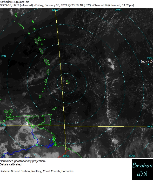
NOAA Latest Satellite Imagery
RAMMB/CIRA SLIDER: GOES-16 Satellite Image
Upper Level WV/IR - North Atlantic
Lower Convergence - North Atlantic
Upper Divergence - North Atlantic
Lower Level IR - North Atlantic
Weathernerds GFS Data
International Model Analyses and Forecasts
GFS Galvez-Davison Index
Sahara Dust Links
Windy: Sahara Dust Model (PM2.5 chosen)
CIMH Sahara Dust Prediction
US Navy NRL/Monterey Aerosol Page (choose Caribbean then NAAPS)
SKIRON Forecast
Other Links
The UWI Seismic Research Centre (official source of information on earthquakes and volcanoes in the English-speaking Eastern Caribbean)
Montserrat Volcano Observatory
VolcanoDiscovery: volcanoes worldwide
Earthquakes around the world - CSEM EMSC - Earthquake monitor | LastQuake App
Earthquakes | U.S. Geological Survey
Latest Earthquakes in Caribbean - U.S. Geological Survey
Flood Map: Elevation Map, Sea Level Rise Map
U.S. Tsunami Warning Centers - tsunami.gov
Sea Level Station Monitoring Facility
World Meteorological Organization (WMO)
International Cloud Atlas Manual on the Observation of Clouds and Other Meteors
(WMO-No. 407)
CISN Display software - earthquakes
Caribbean Catastrophe Risk Insurance Facility (CCRIF)
More to come as I make time!

Recommended Movies

Twisters (2024) |

Supercell (2023) |

All Hail (2022) |

The Guardian (2006) |

The Perfect Storm (2000) |

Volcano (1997) |

Twister (1996) |
|
© 2022 Nigel Romany
|